


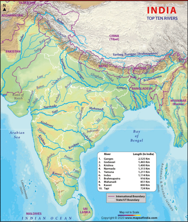
RIVERS OF INDIA WITH THEIR TRIBUTARIES
Complied by Jagdish Chandra
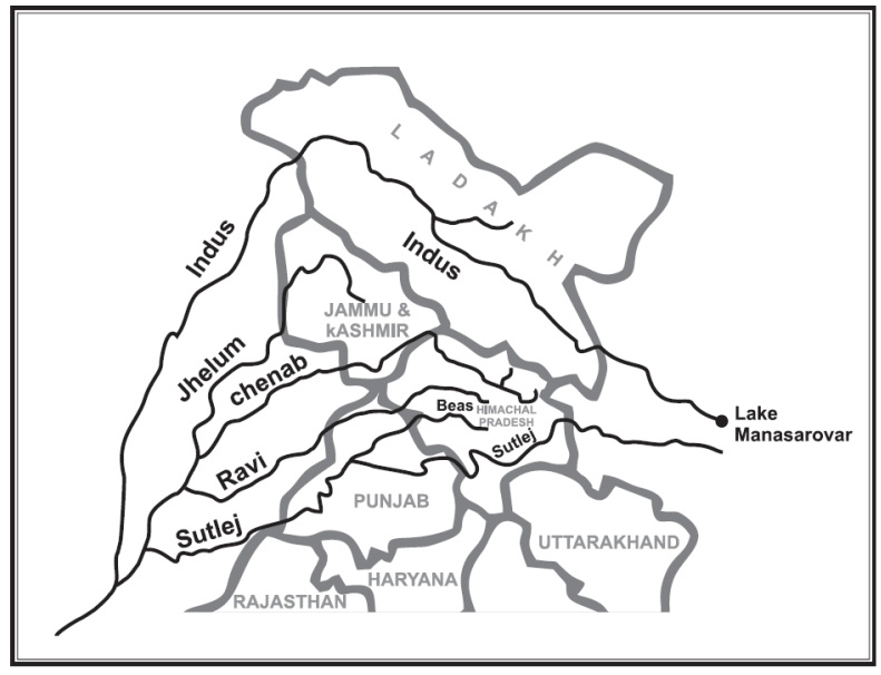
INDUS AND ITS TRIBUTARIES:
• The Indus is one of the most important drainage systems of the subcontinent of India.
• The Indus is the western most River system in the subcontinent.
• Jhelum, Chenab, Ravi, Beas and Satluj are its main tributaries.
• The Indus originates from the Bokhar Chu (glacier) in northern slopes of Mt. Kailash (6714m).
• It drains the largest number of glaciers and mountain slopes of the Karakorum, Ladakh, Zaskarand Himalayan Ranges.
• Originating from the Kailash Mountain, it fl ows in a constricted valley north-westward through Tibet, where it is called as Singi Khamban or Lion’s mouth.
• In ladakh it follows a long nearly straight course between the Ladakh range and the Zaskar range.
• In the first 480 km, it flows along the northern flank of the Zaskar range over a fl at country at heights over 3200 m where it receives River Zaskar below Leh.
• Suruand Dras are the other left bank tributaries which join the Indus near Kargil.
• Moving north-westward, the Indus is joined by the Shyok-Nubra tributaries.
• These tributaries arise from the Siachin Glacier (Karakoram Range).
• At Skardu, at a little distance below the Shyok, the Shigar River meets River Indus.
• Gilgit is another important tributary which comes from the west to join Indus.
• Downward; the Indus crosses the central Himalayan range through a huge synclinal gorge.
• The River passes by the Nanga-Parvat and turns south-west to enter Pakistan
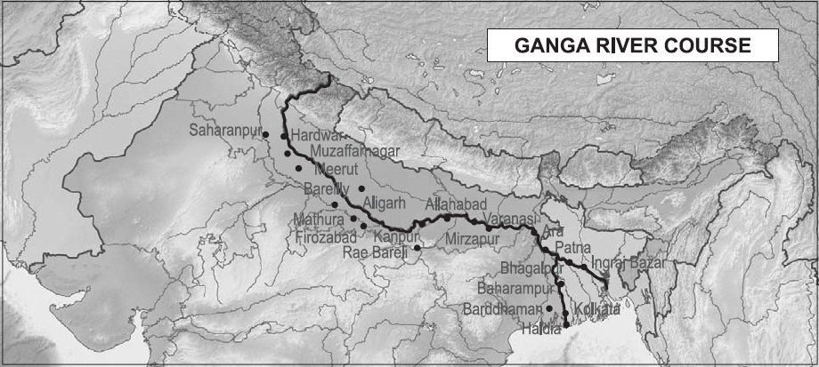
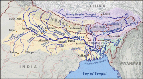
GANGA AND ITS TRIBUTARIES
The Ganga basin is one of the largest river basins.
• It lies in China, Nepal, India and Bangladesh and drains an area of about 10,00,000 sq. kms.
• In India, its catchment lies in the states of Uttar Pradesh, Uttarakhand, Madhya Pradesh, Chhattisgarh, Bihar, Jharkhand Rajasthan, West Bengal, Haryana, Himachal Pradesh and Delhi.
• The Ganga originates as Bhagirathi from the Gangotri Glaciers in the Himalayas at an elevation of about 7,000 m above mean sea level, in the Uttarkashi district of Uttarakhand.
• The Bhagirathi is joined by the Alaknanda at Deoprayag and the combined stream under the name Ganga flowing through the mountain region debouches into the plains at Rishikesh.
• It is joined by a large number of tributaries on both the banks in the course of its total run of about 2,500 km before its outfall into the Bay of Bengal.
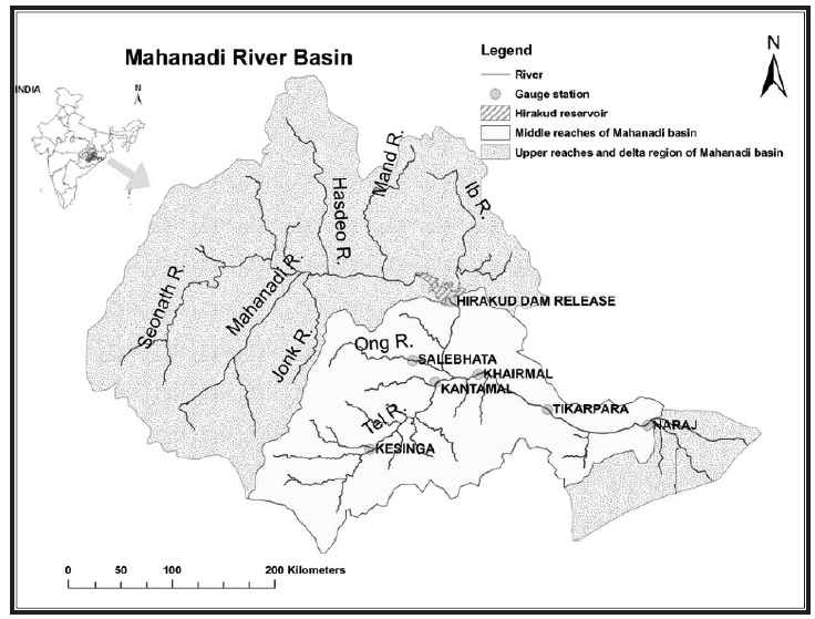
MAHANADI AND ITS TRIBUTARIES:
• The Mahanadi is one of the major east fl owing peninsular rivers draining into Bay of Bengal.
• The Mahanadi River ranks second to the Godavari River among the peninsular rivers in respect of water potential.
• The Mahanadi rises in a pool, 6 km from Pharsiya village near Nagri Town in Raipur district of Chhattisgarh state at an elevation of 457 m.
• The total length of the river form origin to its outfall into Bay of Bengal is 851 km of which 357 km lies in Chhattisgarh and 494 km in Orissa.
• The principal tributaries of the Mahanadi river are; Sheonath, Jonk, Hasdeo, Mand, Ib, Ong and Tel.
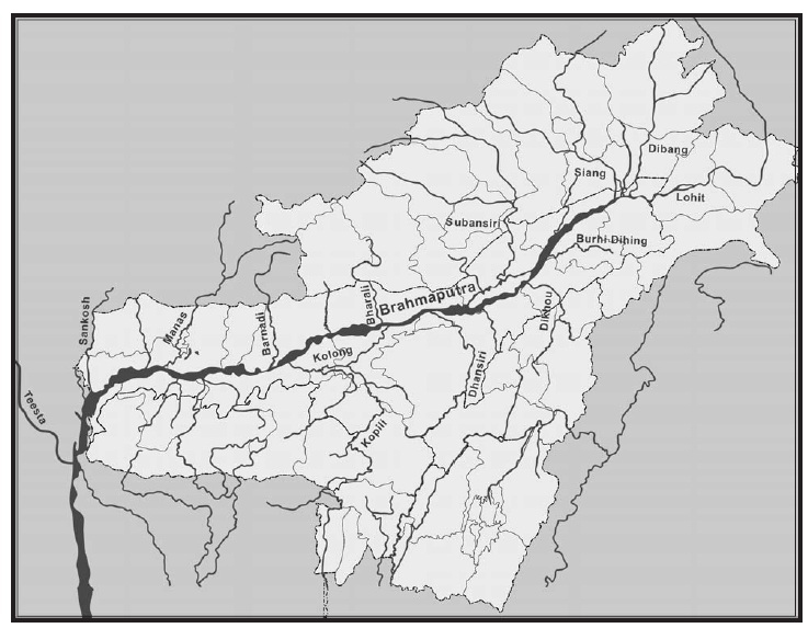
BRAHMAPUTRA & ITS TRIBUTARIES:
• The Brahmaputra Valley has an average width of about 80 Km.
• The main river of the valley, Brahmaputra is one of the largest rivers in the world and rank fifth with respect to its average discharge.
• The river originates from the Kailash ranges of Himalayas at an elevation of 5300 Μ.
• After flowing through Tibet it enters India through Arunachal Pradesh and flows through Assam and Bangladesh before it joins Bay of Bengal.
• Brahmaputra sub-basin extends over an area of 580,000 sq.km lying in Tibet (China), Bhutan, India and Bangladesh.
• The drainage area lying in India is 194413 sq.km which is nearly 5.9% of the total geographical area of the country
• It is bounded on the north by the Himalayas, on the east by the Patkari range of hills running along the Assam-Burma border, on the south by the Assam range of hills and on the west by the Himalayas and the ridge separating it from Ganga sub-basin.
• The sub-basin lies in the States of Arunachal Pradesh, Assam, Nagaland, Meghalaya, West Bengal and Sikkim.
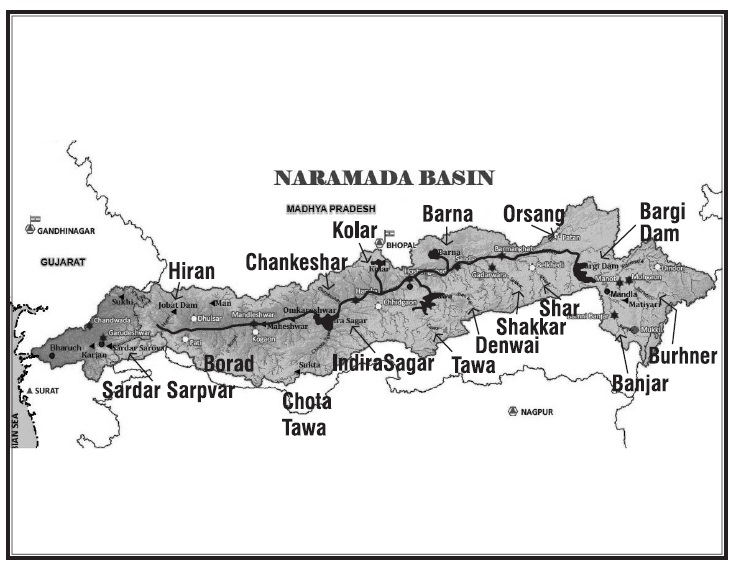
NARMADA & ITS TRIBUTARIES
• Narmada river is the largest west flowing river of the peninsula India. It rises from Narmada Kund, located at Amarkantak, in the Anuppur district of Madhya Pradesh, at an elevation of about 1057 m in the Maikala range. It forms the traditional boundary between North and South India
• The river flows through Madhya Pradesh, Maharashtra and Gujarat between Vindhya and Satpura hill ranges before falling into the Gulf of Cambay in the Arabian Sea about 10 km north of Bharuch, Gujarat. The total length of the river from the head to its outfall into the Arabian Sea is 1,333 km.
• For the first 1085 km, it runs in Madhya Pradesh and thereaer forms the common boundary between Madhya Pradesh and Maharashtra for 39 km, and Maharashtra and Gujarat for 43 km. It has the longest stretch in Gujarat of 166 km.
• There are total 41 tributaries of Narmada river. Out of these, 8 important tributaries join the river from right bank and 11 important tributaries join from the le bank.
• The first major tributary, the Burhner, joins Narmada from left. Further downstream, it receives the Banjar from the left. As Narmada enters the upper fertile plains, it receives the Hiran on the right bank. In continuation, the river receives several tributaries the Sher, the Shakkar, the Dudhi, the Tawa, the Ganjal from the le and the Tendoni, the Barna, the Kolarfrom the right.
• During its journey through the middle plains, it receives tributaries – the Chhota Tawa, the Kundi from the left and the Man from the right. In the lower hilly regions, Narmada receives the Goi from the left and the Uri, the Hatni from the right. The Karjan from the left and the Orsang from the right are important tributaries joining the river in the lower plains. Finally, the river drains into the Gulf of Khambhat (Arabian Sea).
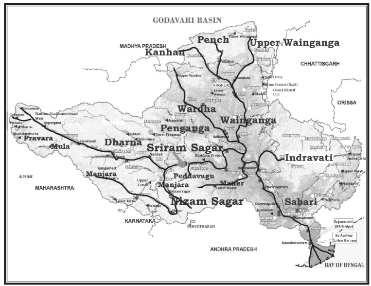
GODAVARI & ITS TRIBUTARIES:
• The river Godavari, the largest of the peninsular rivers, and third largest in India, drains about 10% of India’s total geographical area.
• The catchment area of the river is 3,12,812 sq.km and is spread in the states of Maharashtra (48.6%), Andhra Pradesh (23.4%), Madhya Pradesh (10.0%), Chhattisgarh (10.9%), Orissa (5.7%) and Karnataka (1.4%).
• The river Godavari rises at an elevation of 1,067 m in the Western Ghats near Thriambak Hills in the Nasik district of Maharashtra.
• The largest tributary of the Godavari is the Pranhita with about 34.87% coverage of drainage area. The Pravara, Manjira and Maner are right bank tributaries covering about 16.14%, the Purna, Pranhita, Indravathi and Sabari are important left bank tributaries, covering nearly 59.7% of the total catchment area of the basin.
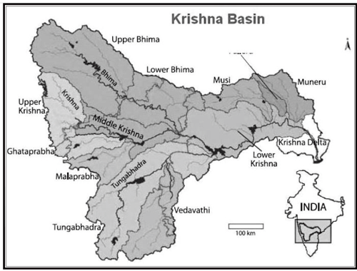
KRISHNA & ITS TRIBUTARIES
• The Krishna Basin extends over Andhra Pradesh, Maharashtra and Karnataka having a total area of 2,58,948 Sq.km which is nearly 8% of the total geographical area of the country.
• It is bounded by Balaghat range on the north, by the Eastern Ghats on the south and the east and by the Western Ghats on the west.
• The Krishna River rises from the Western Ghats near Jor village of Satara district of Maharashtra at an altitude of 1,337 m just north of Mahabaleshwar.
• The total length of river from origin to its outfall into the Bay of Bengal is 1,400 km.
• Its principal tributaries joining from right are the Ghatprabha, the Malprabha and the Tungabhadra whereas those joining from left are the Bhima, the Musi and the Munneru are joining the river from left.
• The major part of basin is covered with agricultural land accounting to 75.86% of the total area and 4.07% of the basin is covered by water bodies.
• The basin spreads over Andhra Pradesh, Karnataka, and Maharashtra.
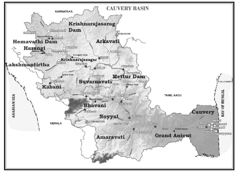
CAUVERY & ITS TRIBUTARIES
• The Cauvery basin extends over states of Tamil Nadu, Karnataka, Kerala and Union Territory of Puducherry draining an area of 81,155 Sq.km which is nearly 2.7% of the total geographical area of the country with a maximum length and width of about 560 km and 245 km.
• It is bounded by the Western Ghats on the west, by the Eastern Ghats on the east and the south and by the ridges separating it from Krishna basin and Pennar basin on the north. The Cauvery River is one of the major rivers of the peninsula.
• Its important tributaries joining from left are the Harangi, the Hemavati, the Shimsha and the Arkavati whereas the Lakshmantirtha, the Kabbani, the Suvarnavati, the Bhavani, the Noyil and the Amaravati joins from right. The river drains into the Bay of Bengal.
• The major part of basin is covered with agricultural land accounting to 66.21% of the total area and 4.09% of the basin is covered by water bodies
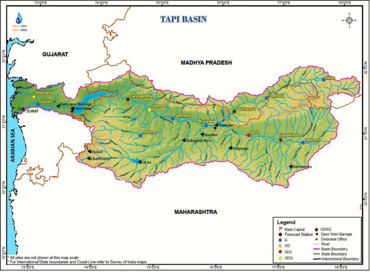
TAPI RIVER:
This river (Length Km724) in central India, rising in the Gawilgarh Hills of the central Deccan plateau in south-central Madhya Pradesh state. It flows westward between two spurs of the Satpura Range across the Jalgaon plateau region in Maharashtra state, and through the plain of Surat in Gujarat state to the Gulf of Khambhat (an inlet of the Arabian Sea). It has a total length of about 435 miles (700 km) and drains an area of 25,200 square miles (65,300 square km). For the last 32 miles (51 km) it is tidal but is navigable by small vessels. The port of Swally Hole, at the river’s mouth, well known in Anglo-Portuguese colonial history, is now deserted, having become silted up. The Tapti flows roughly parallel to the longer Narmada River to the north, from which it is separated by the main part of the Satpura Range. The two river valleys and the intervening range form the natural barrier between northern and peninsular India. The Tapti River’s three major tributaries-the Purna, Girna, and Panjhra-flow from the south in Maharashtra state.
Length (Km): 724
Origin (Source): Satpura Range
Tributaries: Purna River, Girna River, Gomai, Panzara, Pedhi, Arna, Anurati, Suki, Vaghur, Buray, Sipna Discharge its water: Gulf of Khambhat (Arabian Sea)
YAMUNA RIVER:
Yamuna is the main and the longest right bank tributary of river Ganga. It is a snow-fed, braided river which rises from Yamunotri glacier near Banderpoonch peak of the higher Himalaya. After travelling a distance of about 1370 km through Ponta Sahib, Karnal, Panipat, Sonipat, New Delhi, Mathura, Agra, Etawah, Kalpi, Hamirpur and Mau, it joins the Ganga River at Allahabad. The Gambhir, Chambal, Sind, Betwa, Ken, Hindon, Karwan, Sirsa, Arind, Gambhir and Chambal are important tributaries. It is the only major river of India which receives the water and sediments from all physiographic features of India such as the Himalaya, Ganga Plain and the Peninsular Plateau. Length (Km): 1376
Origin (Source): Originates from the Yamunotri glacier at the Banderpoonch peak in the Uttarkashi district of Uttarakhand
Tributaries: (Left tributaries- Hindon, Sharda, Hanuman Ganga, Sasur Khaderi); (Right tributaries- Chambal, Betwa, Giri, Rishiganga, Ken, Sindh, Tons).

Author:
Editor, Publisher and Owner of
ME & MY EARTH Magazine.
A Post graduate in Chemistry & IFS Batch 1990.